
BIM Topography
The Integration of Topography and Technology for High Precision Projects
BIM (Building Information Modeling) topography is the perfect fusion of traditional topography and the most advanced digital tools, offering an integrated and efficient workflow for managing and planning engineering, architecture, and infrastructure projects. At LuftPlan, we utilize cutting-edge technologies, such as aerial photogrammetry with drones and ground surveying equipment, combined with specialized software like Autodesk Civil 3D, Infraworks, Revit, SketchUp, and GIS, to deliver extremely accurate and detailed data.
With this innovative approach, we meet the demands of developers, land developers, construction companies, engineering and architecture firms, and other professionals seeking agility, reliability, and full information integration in their projects.
What is BIM Topography?
BIM topography goes beyond conventional topographic surveying. It involves transforming collected data into an integrated, detailed, three-dimensional (3D) digital model that can be used at different stages of a project. This model is compatible with BIM platforms, enabling a more in-depth and accurate analysis of the terrain, as well as serving as a basis for strategic decision-making.
Our Technologies and Methodology
At LuftPlan, we use a combination of advanced methodologies and high-precision equipment to ensure the delivery of complete and reliable information:
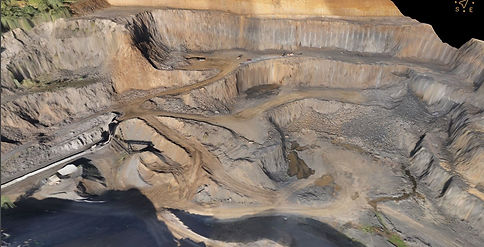
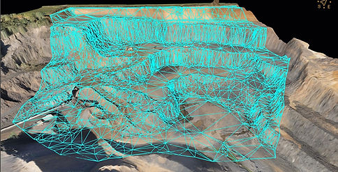
Aerial Photogrammetry with Drones:We carry out fast and accurate topographic surveys, generating orthomosaics with georeferenced contour lines, point clouds, digital terrain models (DTMs) and digital surface models (DSMs) and 3D textured mesh.
With this technology, we capture minute details, even in hard-to-reach areas.
Ground Surveying Equipment:We use GNSS RTK, PPK, RTX, and other state-of-the-art equipment to complement the data obtained by drones. This ensures millimeter accuracy and complements surveys in critical areas.
Specialized Software:We work with market-leading tools, such as:
Autodesk Civil 3D : Detailed modeling and analysis of topographic surfaces, as well as simulations.
Infraworks : Simulations and visualizations for infrastructure projects.
Revit : Perfect integration for BIM projects using TopoSolid, allowing the development of 3D projects.
GIS : Geospatial analysis to understand terrain behavior in the context of the surrounding environment.
Sketchup : The precise integration between terrain and project modeled in 3D.


Possibilities of BIM Topography
A aplicação da Topografia BIM é ampla e adaptável a diferentes necessidades. Confira algumas das principais possibilidades desse serviço:
-
Levantamento Planialtimétrico 3D
Criação de modelos digitais precisos do terreno para projetos de engenharia e arquitetura.
-
Planejamento de Obras e Infraestruturas
Análise de traçados para rodovias, ferrovias, redes de drenagem, lotes e edificações.
Identificação de interferências no terreno que possam impactar a execução do projeto.
-
Integração com Projetos BIM
Dados topográficos detalhados que podem ser incorporados diretamente ao projeto, permitindo a visualização completa da obra em um ambiente virtual.
-
Estudos de Viabilidade
Avaliação de terrenos para novos empreendimentos urbanos, loteamentos ou expansões de infraestrutura.
-
Modelagem Digital do Terreno (MDT)
Produção de modelos tridimensionais para estudos de cortes, aterros e volumes de movimentação de terra.
-
Simulação de Impactos e Estudos Ambientais
Identificação de possíveis impactos ambientais, como alterações no relevo e erosões, antes da execução das obras.
-
Acompanhamento e Monitoramento de Obras
Atualização periódica do modelo BIM com base no levantamento topográfico, garantindo que a obra está alinhada ao projeto inicial.
-
Mapeamento de Lotes, Loteamentos e Glebas
Criação de mapas detalhados para divisão ou unificação de terrenos, com precisão necessária para atender às exigências legais.
-
Controle de Qualidade e Conformidade
Comparação de levantamentos para verificar se o que foi executado está em conformidade com o projeto.
Benefits of Hiring LuftPlan
Choosing LuftPlan for your BIM Topography projects brings a series of benefits, both technical and operational:
1. Unparalleled Accuracy
We use the most modern technologies to provide accurate and detailed data, reducing errors and rework.
2. Agility in Data Collection and Processing
The combination of drones and advanced software enables fast surveys and agile deliveries, saving time without compromising quality.
3. Full Integration with BIM Projects
Our data is optimized for use in BIM platforms, enabling a clear and detailed visualization of the project.
4. Cost Reduction
With process automation and efficiency, our services offer superior value for money, eliminating unnecessary steps.
5. Larger Data Volume
The technology employed allows for the capture of an immense amount of information, ensuring greater detail and support for strategic decisions.
6. Versatility of Applications
Whether for subdivisions, infrastructure projects, urban developments, or engineering and architecture projects, our BIM topography adapts to different demands.