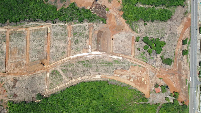
Planialtimetric Survey
Planialtimetric surveying is a crucial step in the development of engineering, architecture and infrastructure projects.
At LuftPlan, we offer complete planialtimetric survey solutions that combine the agility of drones with the precision of ground equipment, ensuring maximum accuracy and the richness of data that only this technology can provide.
With industry experience and a commitment to excellence, our surveys meet the demands of leading urban developments, developers, subdivision developers, and construction companies, providing a solid and reliable foundation for project success.
LuftPlan Planialtimetric Survey
At LuftPlan, we understand that each project is unique and requires detailed information for effective planning. Using advanced drone technology allows us to capture high-resolution data over large areas in a short period of time, while our ground-based equipment ensures the essential precision for each survey point. This combination results in a detailed three-dimensional terrain modeling that supports both topographic calculations and technical planning across a wide range of disciplines.
Main Advantages of Planialtimetric Surveying
High Accuracy and Precision:
LuftPlan offers accurate measurements and reliable data, essential for projects that require meticulous detailing. This is possible thanks to the use of drones with advanced sensors and ground equipment, ensuring that each survey point meets the high accuracy standards required for the execution of complex projects and works.Speed in Data Collection:
The use of drones significantly reduces data collection time, allowing large areas to be surveyed in a matter of hours, unlike traditional methods that can take days or even weeks. For developers and construction companies, this means projects can be started faster and decision-making can be accelerated, optimizing schedules and reducing costs.Volume of Detailed Information:
By combining aerial drone captures with ground-based equipment measurements, we obtain an extremely rich and detailed amount of data. This data is crucial for developers, land developers, and engineering firms to assess all terrain variables, perform elevation and slope analyses, and even plan excavations, earthworks, and much more.Access to Hard-to-Reach Areas:
Drones allow surveying of areas that often present challenges for human access, such as regions with rugged terrain, dense vegetation, or restricted access locations. This provides a comprehensive and unrestricted view of the terrain, ensuring a complete and accurate survey.


Applications of Planialtimetric Surveying
LuftPlan offers planialtimetric surveying as a versatile solution for various project phases, from initial site analysis to construction monitoring and adaptation to changes. Key applications include:
Development of Subdivisions and Urban Projects:
Planialtimetric surveying is essential for topographic analysis, planning the layout of lots, access roads and common areas in an optimized manner, according to the natural conditions of the terrain.Infrastructure Works Planning:
Our surveys are widely used in infrastructure projects, providing accurate data that allows the alignment of roads, railways, bridges, and sanitation networks, always considering the project's conformity with the terrain.Civil Construction and Engineering Works:
Developers and construction companies find in planialtimetric surveys a solid basis for developing foundations, leveling land, and laying out buildings, which contributes to the stability and safety of the project.Architecture and Landscaping Projects:
Architects and landscape designers use topographic data to develop projects that integrate with the natural terrain, respecting the characteristics of the terrain and creating a harmonious integration between the building and the environment.
Innovative Technologies in Surveys
We combine state-of-the-art drones, capable of capturing high-resolution data over large areas, with ground equipment such as RTK (Real-Time Kinematic) GPS, ensuring centimeter-level accuracy.
Drones collect data in real time, while our equipment complements the collection of detailed information from specific points, necessary for validating and complementing the data obtained.
This hybrid survey method offers a fundamental advantage over traditional methods, such as the exclusive use of total stations and ground-based GPS. While conventional methods require more time and involve greater field staff mobilization, surveying with drones and ground-based equipment provides much more efficient data collection and infinitely higher quality, even in hard-to-reach areas.


Benefits of Hiring LuftPlan
Na LuftPlan, entendemos que a precisão é o fator-chave para o sucesso dos projetos topográficos e de engenharia. Nosso compromisso com a qualidade se traduz em uma equipe de especialistas altamente qualificados, tecnologia de ponta e uma abordagem focada em resultados.
Fazemos mais do que simplesmente coletar dados – analisamos, processamos e apresentamos as informações de forma que elas sejam úteis para cada etapa do seu projeto. Nossa experiência com incorporadoras, construtoras e empresas de engenharia nos permite antecipar suas necessidades e adaptar o levantamento de forma que ele atenda a todos os requisitos do setor.
Interessado em saber como nosso levantamento planialtimétrico pode beneficiar seu próximo projeto? Entre em contato com a LuftPlan e descubra como podemos fornecer dados precisos, detalhados e com uma agilidade incomparável.
Conte com a LuftPlan para transformar seus projetos de incorporação, loteamento, engenharia, arquitetura e infraestrutura com informações precisas e confiáveis.
Solicite uma demonstração ou orçamento e saiba mais sobre as soluções que oferecemos para maximizar a eficiência e garantir a qualidade dos seus empreendimentos.